RSS

Monthly Archives: April 2011

1914 Benham car

Benham Manufacturing Company. Detroit, Michigan.

In January 1914 George Benham bought the assets of the S. & M. company and built a slightly modified S. & M. under his own name. It was a handsome car offered in roadster, tourer, and town car models, powered by a 6 cylinder Continental engine. Only 19 cars were made before the company was dissolved. The name survives in a very short street where the car was made, north of East Grand Boulevard (home of Packard).

*article from www.motorsnaps.com

 
Leave a comment

Posted by on April 23, 2011 in Things


Gertrude Emily Benham (1867-1938)

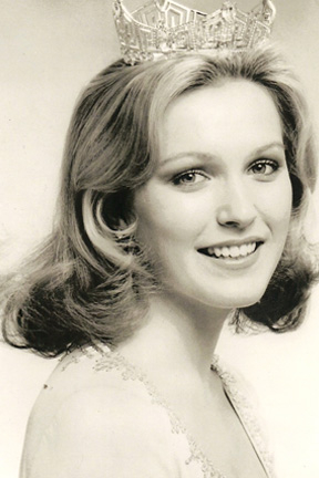
Gertrude Benham was one of the most, possibly the most prolific traveller of all time, and of either sex.

Born in Marylebone, London, Gertrude Benham was the youngest of six children of Frederick Benham, a master ironmonger, and his wife Emily (née Lucas), a native of High Wycombe in Buckinghamshire. As a young girl she accompanied her father on summer holidays in the Alps, and by her twenties she was a skilled mountaineer, making more than 130 ascents and climbing both Mont Blanc and the Matterhorn.

On 27 June, with a Mr Frost and taking the brothers Hans and Christian Kaufmann as guides, she made an ascent of Mount Lefroy. She followed this with ascents of several other major peaks – Mount Victoria, Mount Stephen, Mount Assiniboine and Mount Balfour – then transferred to the Selkirk Range where the Truda Peaks are named in her honour, ascending, among others, Mount Sir Donald. In July 1904, in the company of Christian Kaufmann, she reached the summit of Mount Hejee, narrowly beating Professor Charles Fay, after whom the mountain would subsequently be renamed.

From the Rockies Benham proceeded to Vancouver, and via Fiji arrived in 1905 in New Zealand where she walked alone across the South Island and climbed in the Southern Alps, complaining bitterly about local guides and the exorbitant fees they charged. After visiting Tasmania and Australia, she made her way back to England via Japan (where she made several ascents), India, Egypt and Corsica. In 1908 she set out on her second trip around the world, this time west to east and visiting Japan and California. Following the Pacific coast southward, she disembarked at Valparaíso then crossed the Andes and Pampas to arrive in Buenos Aires. In 1909 she made her way to Central Africa and, after arrival in Broken Hill (now Kabwe in Zambia), walked 900 kilometres to Abercorn (= Mbala) near the southern tip of Lake Tanganyika. From here she proceeded to Uganda and Kenya and made a successful assault on the summit of Mount Kilimanjaro.

Throughout her travels, Benham travelled alone, aided only by porters and carrying with her the Holy Bible, a pocket edition of Shakespeare’s plays, and copies of Kipling’s Kim and Blackmore’s Lorna Doone. She sketched, collected flowers, and sold her knitting and embroidery to pay for the numerous ethnological articles collected along the way, most of which were decorative items displaying particular craft skills.

— — — — — — — — — — —

Female explorer’s forgotten past plumbed in Hacking Antiques at Plymouth College of Art

By artsculture, on Wednesday, February 23, 2011
Hacking Antiques, an exhibition by artist Amy Houghton, offers an insight into the life of oft-overlooked female explorer Gertrude Benham.
In this exhibition, Amy employs artefacts which belonged to Gertrude Benham, an accomplished but little-known explorer from the last century. Gertrude’s achievements included circumnavigating the globe on several occasions and being the first European woman to reach the summit of Africa’s Mount Kilimanjaro.
 
Leave a comment

Posted by on April 22, 2011 in Uncategorized


Benham Plateau

Benham Plateau (coordinates: 17°N 125°ECoordinates: 17°N 125°E), also known as the Benham Rise, is a seismically active undersea region and extinct volcanic ridge east of the Philippines, in the Philippine Sea. Under the Philippine Sea lies a number of Basins including the West Philippine Basin (WPB) of which inside the Basin is located the Central Basin Fault (CBF).[1] The Benham Plateau is located in the CBF and its basement probably represents a micro-continent.[2] Several scientific surveys have been made on the feature to study its nature and its impact on tectonic subduction, including one about its effects on the 1990 Luzon earthquake, which devastated the northern city of Baguio. The area is currently claimed, as part of its continental shelf, by the Republic of the Philippines, which has lodged a claim with the United Nations Commission on the Limits of the Continental Shelf on April 8, 2009.

Territorial waters of the Philippines. The Benham rise is located directly right of Luzon.

Geological features

Benham Rise is a submerged extinct volcanic ridge located at 16 degrees 30 minutes N, 124 degrees 45 minutes E off the coast of Luzon, with the size of about 250km in diameter and rises over 2,000 meters above the sea floor, from below 5,000 meters below sea level to above 3,000 meters below sea level. Its area is close to the Benham Seamount, located at 15 degrees 48 minutes N, 124 degrees 15 minutes E. The precise location is somewhere near the east of the Philippine Trench and near the south of the East Luzon Trench, both of which absorb the subducting force of the Philippine Sea Plate under the Philippine Mobile Belt, [3] a collage of large blocks of that crust that amalgamated prior to the collision of the Philippine Sea Plate with the Eurasian Plate.[4]

The origin of the landform, along with a fellow landform, the Urdaneta Plateau (a remnant of mantle plume), is identified in one study as at least five sequences of propagating rifts, probably triggered by mantle flowing away from the mantle thermal anomaly.[5] Its presence of the landform disrupts the continuity of this region (known as the Philippine-East Luzon Trench) by continuously colliding with the Sierra Madre mountain range of eastern portion of the island of Luzon. Though it is generally thought that the Philippine Sea Plate is being subducted under the Philippine Mobile Belt, under the rules of tectonic subduction, there appears to be a resistance to this because of the presence of the landform, and instead, the plate is being displaced into the northern portion of Luzon to the west. [6][7]

The geophysical features of the plateau may have been the result of an early Miocene collision event between the Benham Rise and the eastern margin of Luzon, which may have also allowed the inception of the NW striking strand of the Philippine fault.[8] These forces may have impacted the shape of the island of Luzon because of the basaltic sea floor resisting the subduction that may have also cause the bending of the Philippine Fault.[9] The active basins in Central Luzon, which trace an asymmetrical V shape, is the best place to observe recent tectonic evolution of the fault system.

History

The landform is presumably named after Admiral Andrew Ellicot Kennedy Benham (1832-1905) by American surveyors who were the probable discoverers of the geological feature. He was a United States Navy officer, who served with both the South Atlantic and West Gulf Blockading Squadrons during the American Civil War.[10] There has been speculation in the scientific community about the nature of the landform. Following the major 16 July 1990 Luzon earthquake, scientists reconsidered their fault models and decided it likely that Benham Plateau has similarly displaced the Philippine Fault System to the west.[11] After analysing older models such as that of Pinet and Stephan (1989), scientists reconsidered their fault models. They thought that it is highly likely that the Benham Plateau is still displacing Central Luzon and the Philippine Fault System to the west, which may have had an impact in causing such a catastrophic earthquake. The 20 second to 50 second wave in the 1990 quake that developed a new east-west sub-fault was so strong that it terminated disastrously at the city of Baguio in Benguet, Cordillera. Several scientific surveys, conducted between 2004 to 2008, collected hydrographic data that determined the morphology of the seabed in the region. Additional data from international bathymetric surveys and an analysis of international research projects were collected to support the findings.

 
Leave a comment

Posted by on April 22, 2011 in Places


Dorothy Benham: Miss America 1977

Dorothy Benham was crowned Miss America 1977 on September 11, 1976.

Dorothy has stayed actively involved in the Miss America program since her year of service. She is a celebrated soprano, whose voice has blessed many preliminary shows as well as several telecasts with her beautiful grace and strong music abilities. Dorothy made her Broadway solo singing debut in 1989 in “Jerome Robbins’ Broadway”. Dorothy is a mother of six who has toured with live orchestras using her beautiful soprano voice to enthrall audiences everywhere. She has appeared numerous times as a musical guest on the national television broadcast “The Hour of Power.” Dorothy has now released 3 CD recordings, including her most recent entitled, “from the heart,” a collection of her favorite Broadway love songs. Dorothy and her husband, Paul Shoemaker, own and operate Dorothy Benham Bridal & Special Occasion, a bridal and women’s formal attire boutique in Minneapolis, Minnesota.

 
Leave a comment

Posted by on April 9, 2011 in People


Benham Falls

Benham Falls are rapids of the Deschutes River located between Sunriver and Bend, Oregon, United States. They are rated an unpassable Class 6 for watercraft, and are cited as the largest falls on the Deschutes.

The falls were created by the eruption of nearby Lava Butte approximately 6,000 years ago, as the lava flow dammed the Deschutes, forming a lake known as Lake Benham.[2] The river eventually flowed over the dam, draining the lake and thus forming Benham Falls. Around 1885, J. R. Benham attempted and failed to file a land claim near the falls, though they were later named for him.[3]

Today, there are forest roads connecting Benham Falls to Lava Butte, Lava River Cave, and Sunriver Resort. A footbridge connects the forest road to an easy-to-navigate trail near the river and falls.[4] The shady area has lots of wildlife and flowers.[2] Because of this, the area also has mosquitoes. Additionally, the United States Forest Service has established a few lookouts over the gorge for viewers. Hikers and mountain bikers who continue on this trail pass Dillon Falls and Lava Island Falls, and eventually, the city of Bend. Benham Falls is relatively easier to see compared to the falls downstream, because it isn’t surrounded by lava flow from Lava Butte, but surrounded by forest. Because of its location, it is also much more popular.

Benham Falls is also in the Deschutes National Forest and the Newberry National Volcanic Monument. Benham Falls Recreation Site and Benham Falls West Recreation Site are located nearby.

 
Leave a comment

Posted by on April 3, 2011 in Places